Praia de Tróia (Rio) Beach
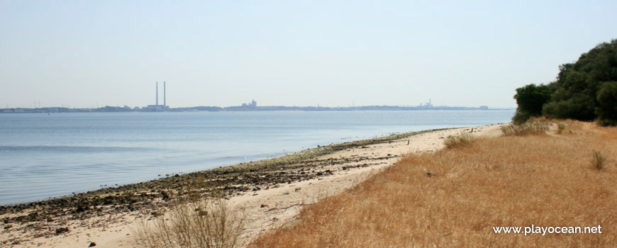
Fluvial sands of Praia de Tróia (River) Beach, alongside Tróia Marina.
Weather and Tide Table
Sunset
Sunrise
to Low Tide
Low Tide
High Tide
70% | 1,2 m 3.9 ft | Low Tide | |
68% | 2,6 m 8.5 ft | High Tide | |
66% | 1,4 m 4.6 ft | Low Tide | |
63% | 2,8 m 9.2 ft | High Tide | |
61% | 1,4 m 4.6 ft | Low Tide | |
58% | 2,5 m 8.2 ft | High Tide | |
55% | 1,5 m 4.9 ft | Low Tide | |
53% | 2,6 m 8.5 ft | High Tide | |
50% | 1,4 m 4.6 ft | Low Tide | |
47% | 2,4 m 7.9 ft | High Tide | |
44% | 1,6 m 5.2 ft | Low Tide | |
41% | 2,7 m 8.9 ft | High Tide | |
38% | 1,3 m 4.3 ft | Low Tide | |
36% | 2,6 m 8.5 ft | High Tide | |
33% | 1,4 m 4.6 ft | Low Tide | |
30% | 2,8 m 9.2 ft | High Tide | |
28% | 1,1 m 3.6 ft | Low Tide | |
25% | 2,8 m 9.2 ft | High Tide | |
23% | 1,2 m 3.9 ft | Low Tide | |
20% | 3,0 m 9.8 ft | High Tide | |
18% | 0,9 m 3 ft | Low Tide | |
15% | 3,1 m 10.2 ft | High Tide | |
13% | 0,9 m 3 ft | Low Tide | |
11% | 3,3 m 10.8 ft | High Tide | |
9% | 0,6 m 2 ft | Low Tide | |
8% | 3,3 m 10.8 ft | High Tide | |
6% | 0,7 m 2.3 ft | Low Tide | |
5% | 3,5 m 11.5 ft | High Tide | |
3% | 0,4 m 1.3 ft | Low Tide | |
2% | 3,5 m 11.5 ft | High Tide | |
1% | 0,5 m 1.6 ft | Low Tide | |
1% | 3,7 m 12.1 ft | High Tide | |
0% | 0,3 m 1 ft | Low Tide | |
0% | 3,6 m 11.8 ft | High Tide | |
0% | 0,3 m 1 ft | Low Tide | |
0% | 3,7 m 12.1 ft | High Tide | |
1% | 0,3 m 1 ft | Low Tide | |
1% | 3,7 m 12.1 ft | High Tide | |
2% | 0,3 m 1 ft | Low Tide | |
3% | 3,7 m 12.1 ft | High Tide | |
4% | 0,4 m 1.3 ft | Low Tide | |
5% | 3,6 m 11.8 ft | High Tide | |
7% | 0,4 m 1.3 ft | Low Tide | |
About the Beach
What is Praia de Tróia (Rio) Beach?
It's an Oceanic Beach in the northern hemisphere bathed by the Atlantic Ocean, located on the coast of Portugal - Iberian Peninsula - in the municipality of Grândola.
Praia de Tróia (River) Beach belongs to the Rio Sado1 mouth by the south margin. It has a strip of sand with about 1,8 Km. The waters are calm due to the protection provided by the peninsula.
The beach is west bounded by Marina de Tróia2.
There's a small estuary in the south area integrated in the northeast part of the Reserva Natural do Estuário do Sado3o.
Far away, on the other side of the river, may be seen Setúbal city which is possible of reaching by ferry boat.
References
- Sado River
- Tróia Marina
- Sado Estuary Natural Reserve
Where is it?
Map of Praia de Tróia (Rio) Beach
| Coordinates Decimal Degrees (Lat/Long WGS84) Degrees, Decimal Minutes (Lat/Long WGS84) Degrees, Minutes, Seconds (Lat/Long WGS84) |
Lat. 38.493895º Lon. -8.899236º N 38º 29.6337' W 8º 53.95416' N 38º 29' 38.02" W 8º 53' 57.25" |
| Parish | Carvalhal |
| County | Grândola |
| District | Setúbal |
| Region | Baixo Alentejo |
| Country | Portugal |
| Continent | Europe |
| Ocean | North Atlantic |
| Maritime Authority | Capitania do Porto de Setúbal |
| Protected Area | |
| Bathing Water | |
| Coastal Unit | Outão - Praia da Rapousa (Pinheiro da Cruz) |
| Coastal Region | Costa Azul |
Awards
| Award | 2017 | 2016 | 2015 | 2014 | 2013 | 2012 | 2011 | 2010 | 2009 | 2008 | 2007 | 2006 |
|---|---|---|---|---|---|---|---|---|---|---|---|---|
| Water Quality | ||||||||||||
| Blue Flag | ||||||||||||
| Gold Flag | ||||||||||||
| Handicapped-Accessible Beach | ||||||||||||
| Zero Polution |