Praia de Salir do Porto Beach
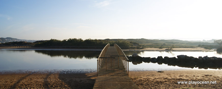
Pedestrian bridge over the Tornada or Salir River.
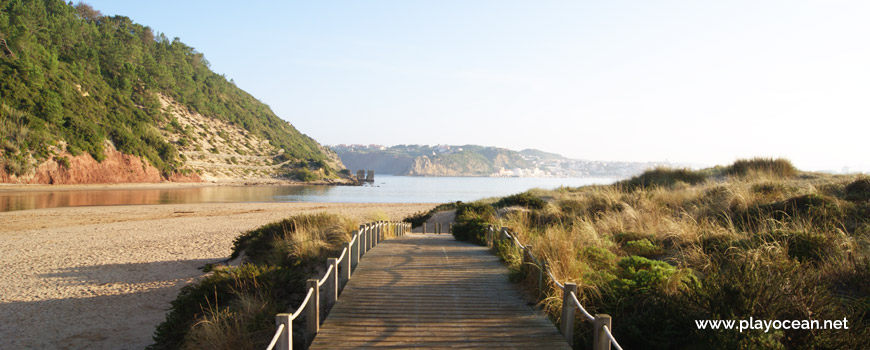
Wooden walkway along the margin of the Tornada or Salir River.
Weather and Tide Table
First Quarter Moon
Blustery
06h10
Sunrise
Sunrise
21h03
Sunset
Sunset
Seg
12 - 20
Ter
13 - 19
Qua
13 - 20
Qui
14 - 19
Sex
14 - 21
16
ºC
Air Temperature
N
28
km/h
Wind Speed and Direction
73
%
Relative Humidity
1017
mbar
Atmospheric Pressure
40%
Flood Tide
03h52
to High Tide
to High Tide
15:21
Low Tide
Low Tide
21:50
High Tide
High Tide
No Data
Water Temperature
No Data
Wave Direction
No Data
Wave Medium Height
No Data
Wave Medium Period
45% | 1,2 m 3.9 ft | Low Tide | |
48% | 2,6 m 8.5 ft | High Tide | |
50% | 1,4 m 4.6 ft | Low Tide | |
53% | 2,8 m 9.2 ft | High Tide | |
56% | 1,3 m 4.3 ft | Low Tide | |
58% | 2,5 m 8.2 ft | High Tide | |
61% | 1,5 m 4.9 ft | Low Tide | |
63% | 2,8 m 9.2 ft | High Tide | |
66% | 1,2 m 3.9 ft | Low Tide | |
68% | 2,6 m 8.5 ft | High Tide | |
71% | 1,4 m 4.6 ft | Low Tide | |
73% | 2,8 m 9.2 ft | High Tide | |
75% | 1,2 m 3.9 ft | Low Tide | |
77% | 2,7 m 8.9 ft | High Tide | |
79% | 1,3 m 4.3 ft | Low Tide | |
81% | 2,9 m 9.5 ft | High Tide | |
83% | 1,1 m 3.6 ft | Low Tide | |
85% | 2,9 m 9.5 ft | High Tide | |
87% | 1,1 m 3.6 ft | Low Tide | |
88% | 3,0 m 9.8 ft | High Tide | |
90% | 1,0 m 3.3 ft | Low Tide | |
91% | 3,0 m 9.8 ft | High Tide | |
93% | 1,0 m 3.3 ft | Low Tide | |
94% | 3,1 m 10.2 ft | High Tide | |
95% | 0,9 m 3 ft | Low Tide | |
96% | 3,1 m 10.2 ft | High Tide | |
97% | 0,9 m 3 ft | Low Tide | |
98% | 3,1 m 10.2 ft | High Tide | |
98% | 0,9 m 3 ft | Low Tide | |
99% | 3,2 m 10.5 ft | High Tide | |
99% | 0,9 m 3 ft | Low Tide | |
100% | 3,1 m 10.2 ft | High Tide | |
100% | 0,8 m 2.6 ft | Low Tide | |
100% | 3,2 m 10.5 ft | High Tide | |
100% | 0,8 m 2.6 ft | Low Tide | |
100% | 3,1 m 10.2 ft | High Tide | |
100% | 0,9 m 3 ft | Low Tide | |
99% | 3,2 m 10.5 ft | High Tide | |
99% | 0,8 m 2.6 ft | Low Tide | |
98% | 3,1 m 10.2 ft | High Tide | |
97% | 0,9 m 3 ft | Low Tide | |
96% | 3,2 m 10.5 ft | High Tide | |
96% | 0,9 m 3 ft | Low Tide | |
About the Beach
What is Praia de Salir do Porto Beach?
Lifeguarded Beach from to
days for the start of bathing season
It's an Oceanic Beach in the northern hemisphere bathed by the Atlantic Ocean, located on the coast of Portugal - Iberian Peninsula - in the municipality of Caldas da Rainha.
Praia de Salir do Porto Beach belongs to the mouth of the Rio Tornada or Rio Salir1 by the south side.
The very long sand is wider in the southern area and gets narrower into north direction.
This beach is known because of its gigantic dune of about 50 meters high, the tallest of all Portugal.
Access is done by crossing Salir do Porto, turning west at the roundabout to Rua Dom Fernando2.
References
- Tornada River
- Dom Fernando Street
Where is it?
Map of Praia de Salir do Porto Beach
| Coordinates Decimal Degrees (Lat/Long WGS84) Degrees, Decimal Minutes (Lat/Long WGS84) Degrees, Minutes, Seconds (Lat/Long WGS84) |
Lat. 39.503029º Lon. -9.146126º N 39º 30.18174' W 9º 8.76756' N 39º 30' 10.9" W 9º 8' 46.05" |
| Parish | Salir do Porto |
| County | Caldas da Rainha |
| District | Leiria |
| Region | Estremadura |
| Country | Portugal |
| Continent | Europe |
| Ocean | North Atlantic |
| Maritime Authority | Capitania do Porto de Peniche |
| Protected Area | |
| Bathing Water | |
| Coastal Unit | Ponta do Facho (São Martinho do Porto) - Pedra da Aberta (Lagoa de Óbidos) |
| Coastal Region | Costa de Prata |
Awards
| Award | 2017 | 2016 | 2015 | 2014 | 2013 | 2012 | 2011 | 2010 | 2009 | 2008 | 2007 | 2006 |
|---|---|---|---|---|---|---|---|---|---|---|---|---|
| Water Quality | ||||||||||||
| Blue Flag | ||||||||||||
| Gold Flag | ||||||||||||
| Handicapped-Accessible Beach | ||||||||||||
| Zero Polution |
Documents
Reviews
Login to Review.
or start session at
.