Praia do Portinho do Forno Beach
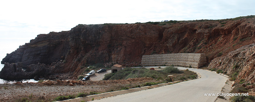
Descent to Praia do Portinho do Forno Beach.
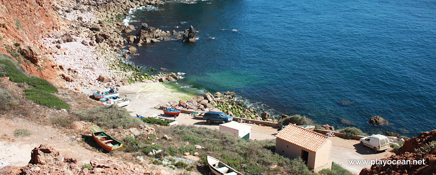
Fishermen vessels at Praia do Portinho do Forno Beach.
Weather and Tide Table
Sunrise
Sunset
to High Tide
Low Tide
High Tide
11% | 3,6 m 11.8 ft | High Tide | |
13% | 0,5 m 1.6 ft | Low Tide | |
15% | 3,5 m 11.5 ft | High Tide | |
17% | 0,6 m 2 ft | Low Tide | |
20% | 3,4 m 11.2 ft | High Tide | |
22% | 0,8 m 2.6 ft | Low Tide | |
25% | 3,3 m 10.8 ft | High Tide | |
27% | 0,8 m 2.6 ft | Low Tide | |
30% | 3,1 m 10.2 ft | High Tide | |
33% | 1,1 m 3.6 ft | Low Tide | |
35% | 3,0 m 9.8 ft | High Tide | |
38% | 1,1 m 3.6 ft | Low Tide | |
41% | 2,7 m 8.9 ft | High Tide | |
44% | 1,3 m 4.3 ft | Low Tide | |
47% | 2,8 m 9.2 ft | High Tide | |
50% | 1,3 m 4.3 ft | Low Tide | |
53% | 2,5 m 8.2 ft | High Tide | |
55% | 1,5 m 4.9 ft | Low Tide | |
58% | 2,7 m 8.9 ft | High Tide | |
61% | 1,3 m 4.3 ft | Low Tide | |
64% | 2,5 m 8.2 ft | High Tide | |
66% | 1,5 m 4.9 ft | Low Tide | |
69% | 2,7 m 8.9 ft | High Tide | |
71% | 1,2 m 3.9 ft | Low Tide | |
74% | 2,6 m 8.5 ft | High Tide | |
76% | 1,4 m 4.6 ft | Low Tide | |
78% | 2,9 m 9.5 ft | High Tide | |
80% | 1,1 m 3.6 ft | Low Tide | |
82% | 2,7 m 8.9 ft | High Tide | |
84% | 1,2 m 3.9 ft | Low Tide | |
86% | 3,0 m 9.8 ft | High Tide | |
88% | 1,0 m 3.3 ft | Low Tide | |
89% | 2,9 m 9.5 ft | High Tide | |
91% | 1,1 m 3.6 ft | Low Tide | |
92% | 3,1 m 10.2 ft | High Tide | |
93% | 0,9 m 3 ft | Low Tide | |
95% | 3,0 m 9.8 ft | High Tide | |
96% | 0,9 m 3 ft | Low Tide | |
97% | 3,2 m 10.5 ft | High Tide | |
97% | 0,8 m 2.6 ft | Low Tide | |
98% | 3,1 m 10.2 ft | High Tide | |
99% | 0,8 m 2.6 ft | Low Tide | |
About the Beach
What is Praia do Portinho do Forno Beach?
It's an Oceanic Beach in the northern hemisphere bathed by the Atlantic Ocean, located on the coast of Portugal - Iberian Peninsula - in the municipality of Aljezur.
Praia do Portinho do Forno Beach as a small sized sand that is used as an harbor for the fishermen community of Carrapateira village. There's a ramp to place and remove boats from the water, at the north area.
The bottom of the sandy cliff has unstable appearance, showing the occurrence of landslides due to rocks accumulation.
The access is done by exiting Estrada Nacional 2681 to southeast for 1,5 Km, until one finds Sítio do Forno restaurant in the middle of the Pontal da Carrapateira.
References
- National Road 268
Where is it?
Map of Praia do Portinho do Forno Beach
| Coordinates Decimal Degrees (Lat/Long WGS84) Degrees, Decimal Minutes (Lat/Long WGS84) Degrees, Minutes, Seconds (Lat/Long WGS84) |
Lat. 37.174270º Lon. -8.907828º N 37º 10.4562' W 8º 54.46968' N 37º 10' 27.37" W 8º 54' 28.18" |
| Parish | Bordeira |
| County | Aljezur |
| District | Faro |
| Region | Algarve |
| Country | Portugal |
| Continent | Europe |
| Ocean | North Atlantic |
| Maritime Authority | Capitania do Porto de Lagos |
| Protected Area | Parque Natural do Sudoeste Alentejano e Costa Vicentina |
| Bathing Water | |
| Coastal Unit | Pontal - Cabo São Vicente |
| Coastal Region | Costa Vicentina |
Awards
| Award | 2017 | 2016 | 2015 | 2014 | 2013 | 2012 | 2011 | 2010 | 2009 | 2008 | 2007 | 2006 |
|---|---|---|---|---|---|---|---|---|---|---|---|---|
| Water Quality | ||||||||||||
| Blue Flag | ||||||||||||
| Gold Flag | ||||||||||||
| Handicapped-Accessible Beach | ||||||||||||
| Zero Polution |